








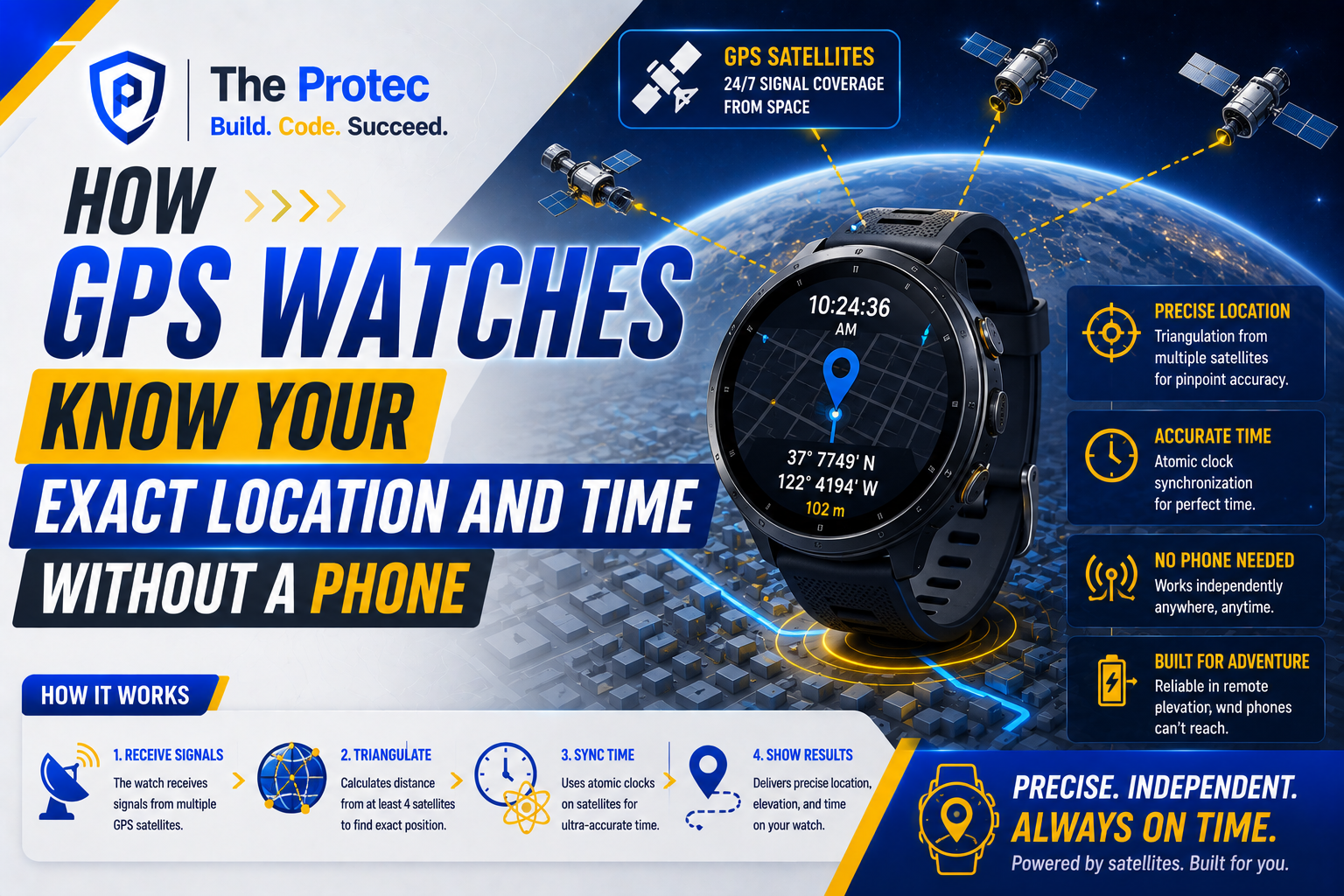
Leave your phone at home, start an outdoor workout, and a modern GPS watch can still map your route, measure your pace, and display remarkably accurate time. That independence can feel surprising because phone apps and wireless connections are so deeply integrated into everyday wearable technology. The explanation is simple: your phone is helpful, but it is not the source of GPS.
A GPS watch contains its own miniature radio receiver and computing hardware. It listens to precisely timed signals transmitted by navigation satellites, calculates how far away those satellites are, and uses that information to determine its position. The same signals also provide an extraordinarily stable time reference based on atomic clocks.
Understanding how GPS watches work requires separating three related functions: receiving satellite signals, solving for location, and maintaining time. Assisted GPS and onboard sensors can make the process faster or smoother, but a phone connection is not normally required for the core calculation.
How GPS Watches Work With Satellite Signals
GPS, or the Global Positioning System, is one part of the broader category known as global navigation satellite systems, or GNSS. Other operational constellations include Galileo, GLONASS, BeiDou, and Japan’s regional QZSS. Many current watches are multi-GNSS devices, meaning they can receive signals from several constellations rather than relying exclusively on GPS satellites.
Each navigation satellite repeatedly broadcasts a radio message containing its orbital information, satellite status, and the exact time the message was transmitted. The watch does not send a request to the satellite. It is a passive receiver, much like a radio tuned to an extremely precise broadcast.
After receiving a signal, the watch compares the transmitted timestamp with the time at which the signal arrived. Radio waves travel at approximately the speed of light, so even a tiny timing difference represents a measurable distance. Multiplying the signal’s travel time by the speed of light gives the watch an estimated range to that satellite.
These measurements are called pseudoranges because they initially contain errors caused by the watch’s imperfect clock, the atmosphere, reflected signals, and orbital uncertainties. The receiver’s job is to solve for those errors while calculating a useful position.
How GPS Watch Location Tracking Calculates a Position
One satellite can indicate that the watch is somewhere on a vast sphere around that satellite. A second and third satellite narrow the possibilities, but a typical three-dimensional position and clock solution requires signals from at least four satellites.
Using four or more pseudoranges, the watch solves for latitude, longitude, altitude, and its own clock offset. This process is often casually called triangulation, although satellite navigation more accurately uses trilateration or multilateration because it relies on measured distances rather than angles.
In open terrain, a watch may see far more than four satellites. Extra measurements improve the solution and allow the receiver to reject weak or inconsistent data. Satellite geometry matters as well: signals spread across the sky generally produce a better result than signals clustered in one direction.
Real-world accuracy is affected by trees, cliffs, tall buildings, weather-related atmospheric conditions, antenna design, and multipath interference. Multipath occurs when a signal reflects from a surface before reaching the watch, making the route appear longer. According to the official GPS accuracy guidance, device quality and the user’s surroundings play major roles in the final result.
Why GPS Watch Time Accuracy Is So High
Navigation satellites must agree on time with exceptional precision. Their onboard atomic clocks use stable atomic transitions as frequency references, while ground-control systems monitor the constellation and upload corrections. A timing error of only one microsecond would translate into a ranging error of roughly 300 meters.
Your watch does not contain a satellite-grade atomic clock. Instead, its GNSS receiver uses the satellite broadcasts to estimate and correct the offset in its much less expensive internal clock. Once the receiver has a valid fix, it can synchronize the displayed time with a highly accurate reference.
GPS maintains its own continuous timescale, which is not identical to Coordinated Universal Time because UTC accounts for leap seconds. Navigation messages provide the information receivers need to derive UTC, while the watch’s software applies the selected time zone and daylight-saving rules. Organizations such as the National Institute of Standards and Technology explain how atomic clocks support modern timekeeping systems.
Between satellite fixes, the watch relies on an internal quartz oscillator or another low-power timing component. That clock can drift slightly because of temperature, age, and manufacturing tolerances. Periodic GNSS synchronization corrects the drift, which is why GPS watch time accuracy remains strong even when the watch spends long periods away from a phone.
What Happens When You Use a GPS Watch Without a Phone?
A GPS watch without phone connectivity can still receive satellite signals, calculate coordinates, record a track, determine speed and distance, and synchronize its time. Those functions happen on the watch. Cellular service, Wi-Fi, Bluetooth, and mobile data are not required for the satellites to be heard.
However, losing the phone connection can affect convenience and startup speed. A connected watch may previously have downloaded current satellite orbit predictions, time estimates, and approximate location data. Without that assistance, it may need to obtain more information directly from the satellites.
A cold start occurs when the receiver lacks a reliable recent position, accurate time, or current orbital data. It must search a wider range of signals and download navigation information over a slow radio link. This can take from tens of seconds to several minutes, especially under trees or near buildings. A warm or hot start is faster because the watch already knows approximately where it is, what time it is, and which satellites should be visible.
Once the watch gets a fix, it can store the route in onboard memory. What it cannot necessarily do without a phone or cellular connection is upload the activity, share live tracking, retrieve cloud-based maps, send ordinary internet messages, or download updated assistance data. Watches with offline maps can still display those maps, while cellular or satellite-messaging features are separate from GNSS positioning.
Assisted GPS Makes the First Fix Faster
Assisted GPS, commonly shortened to A-GPS or AGPS, does not replace satellite positioning. It supplies useful starting information through a phone, Wi-Fi connection, or the watch’s own cellular service. Depending on the platform, this may include approximate location, precise time, satellite almanac data, or predicted orbital information.
With those clues, the receiver knows which satellites and signal frequencies to search. That reduces time to first fix and may also lower energy consumption because the radio does not need to search for as long. Some wearable brands periodically download extended prediction files that remain useful for several days.
If those files expire while the watch is offline, GPS should still work. The initial lock may simply take longer. For the best standalone result, move outdoors, wait with a clear view of the sky, and allow the watch to confirm a position before starting an activity.
How Onboard Sensors Support Location Tracking
Satellite signals are the primary source of absolute outdoor position, but watches combine them with onboard sensors to produce a steadier track. An accelerometer detects motion and steps, a gyroscope measures rotation, a barometric altimeter estimates elevation changes, and an electronic compass provides heading information when calibrated correctly.
Sensor fusion software compares these measurements with GNSS data. If signals briefly weaken in a tunnel, under dense foliage, or between high-rise buildings, motion sensors can help estimate how the wearer continued moving. A barometer can produce more responsive ascent and descent readings than satellite altitude alone.
This process is often described as dead reckoning. It can bridge short gaps, smooth an erratic pace reading, and reject implausible jumps, but its errors accumulate over time. Sensors cannot provide an indefinitely accurate global position without an external reference such as GNSS. When satellite reception returns, the watch uses the new fix to correct its estimate.
Modern Multi-Band GPS Watches Improve Difficult Tracks
As of August 2026, multi-constellation and dual-frequency reception have become increasingly common in performance watches. Traditional consumer receivers primarily used the L1 band. Newer multi-band models can also process signals such as GPS L5, which offers a wider bandwidth and improved resistance to some reflected-signal errors.
Using more constellations and frequencies gives a watch additional measurements in difficult environments. This is particularly valuable around glass buildings, in mountain valleys, and beneath partial tree cover. Manufacturers are also using adaptive modes that choose between single-band, multi-band, and reduced-power tracking according to current conditions.
These improvements do not make the watch immune to obstruction. GNSS signals arrive at Earth with very low power, and water, metal roofs, concrete, and indoor structures can block them. Multi-band technology improves the receiver’s ability to identify cleaner measurements; it cannot create a direct satellite path where none exists.
Why Battery Life Changes With GPS Mode
Continuous location tracking consumes more energy than displaying time because the watch must operate its radio, process multiple signal channels, run positioning calculations, and write track points to memory. Multi-band modes usually consume more power than basic single-frequency tracking.
Battery-saving modes may reduce how often the receiver calculates a position, limit the number of constellations used, or combine occasional fixes with motion-sensor estimates. This extends runtime but can cut corners, smooth switchbacks, or report less precise pace data.
For an ordinary run, a balanced automatic mode often provides sufficient accuracy. Multi-band tracking is most useful in locations known for reflection or blockage. Long expeditions may benefit from an endurance mode, provided the user accepts lower track detail.
Frequently Asked Questions
Can a GPS watch track location with the phone turned off?
Yes. If the watch has an integrated GNSS receiver, it can calculate and record its location while the phone is turned off or left behind. A phone may accelerate the first fix and provide maps, uploads, or live-sharing services, but it is not required for basic satellite positioning.
Does a GPS watch need a SIM card or subscription?
No subscription or SIM card is needed to receive standard GPS and other open GNSS signals. A subscription may be required for cellular data, emergency satellite messaging, cloud features, or live location sharing. Those communication services are distinct from determining coordinates.
Why does my watch sometimes take longer to find GPS?
The receiver may have outdated orbital assistance data, an inaccurate starting time, or a poor view of the sky. Traveling a long distance while the watch is off can also increase search time. Go outside, move away from buildings, keep the watch still, and wait for a confirmed lock.
Will a GPS watch show the correct time indoors?
Usually, yes. After synchronization, the internal clock keeps running when satellite signals are unavailable. It may drift slightly over a long period, but the next GNSS, phone, Wi-Fi, or network synchronization can correct it. Automatic time-zone changes may require a position fix or updated zone information.
Is phone GPS more accurate than watch GPS?
Not always. Phones can combine GNSS with cellular, Wi-Fi, and larger antennas, while premium watches may offer optimized outdoor antennas, dual-frequency reception, and sports-specific sensor fusion. Accuracy depends on the hardware, operating mode, placement, surroundings, and quality of the software processing the measurements.
The Key Point
A GPS watch knows where and when it is because it carries a standalone satellite receiver. Atomic-clock-based broadcasts provide the timing foundation, measurements from multiple satellites produce a position, and onboard sensors help maintain a smooth track. A phone makes the experience faster and more connected, but the essential location and time calculations happen directly on your wrist.